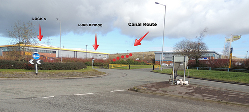
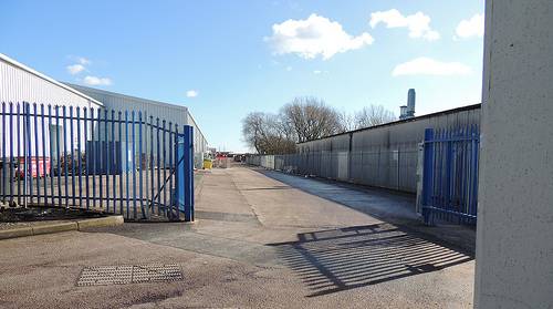
 CB20 Rumer Hill Junction
(Use pointer ---- 52.6784, -2.0125 in https://www.google.co.uk/maps )
The site of lock 5 is under
the Finning CAT building.
Lock Bridge between locks 5 and 4 would have been level
with the back wall of the building. The remaining locks
running up to the Rumer Hill Junction on BCN Cannock
Extension would have been under the landfill mound.
This photo taken from Orbital Way looking north -
22/2/2016.
------ (More Photos in my Flickr album - Churchbridge
Branch Canal)
( Use pointer ---- 52.6783, -2.0130 in https://www.google.co.uk/maps )
(Use pointer ---- 52.6779, -2.0136 in https://www.google.co.uk/maps )
(use pointer ---- 52.6776, -2.0144 in https://www.google.co.uk/maps )
(Use pointer ---- 52.6770, -2.0152 in https://www.google.co.uk/maps )
(Use pointer ---- 52.6769, -2.0154 in https://www.google.co.uk/maps )
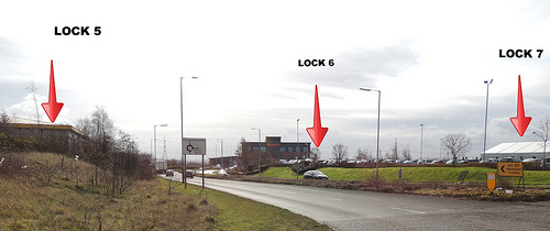 CB80 Churchbridge Flight - Lock
5
CB80 Churchbridge Flight - Lock
5(Use pointer ---- 52.6766, -2.0160 in https://www.google.co.uk/maps )
The site of lock 5 is under
the Finning CAT building.
The site of lock 6 is under the Briggs Equipment car park.
The site of lock 7 is under the white Briggs Equipment
building.
This photo taken of Orbital Way running south-east
- 22/2/2016.
------ (More Photos in my Flickr album - Churchbridge
Branch Canal)
(Use pointer ---- 52.6762, -2.0168 in https://www.google.co.uk/maps )
(Use pointer ---- 52.6758, -2.0175 in https://www.google.co.uk/maps )
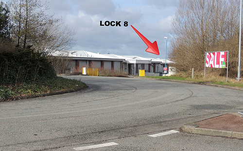 CB110 Churchbridge Flight - Lock
8
CB110 Churchbridge Flight - Lock
8(Use pointer ---- 52.6753, -2.0182 in https://www.google.co.uk/maps )
Lock 8 would have been under the access road Gemini Drive at the rear of the Orbital Retail Park.
This photo looking towards Gemini Drive -
22/2/2016.
------ (More Photos in my Flickr album - Churchbridge
Branch Canal)
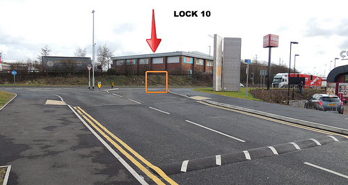
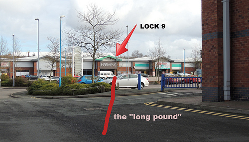 CB120 Churchbridge Flight - Lock
9
CB120 Churchbridge Flight - Lock
9(Use pointer ---- 52.6750, -2.0189 in https://www.google.co.uk/maps )
Taken at the site of Lock 10 at the side of Argos (unit 8) of the Orbital Retail Park.
Ahead is the "long pound" leading to Lock 9 that would have been under Harveys (unit 5) of the Orbital Retail Park.
This photo looking north-east - 22/2/2016.
------ (More Photos in my Flickr album - Churchbridge
Branch Canal)
 CB140 Churchbridge Flight - Lock
10
CB140 Churchbridge Flight - Lock
10(Use pointer ---- 52.6740, -2.0208 in https://www.google.co.uk/maps )
The site of Lock 10 at the rear corner of Argos (unit 8) of the Orbital Retail Park.
This photo taken from the entrance to Gateway
Retail Park looking north-east - 22/2/2016.
------ (More Photos in my Flickr album - Churchbridge
Branch Canal)
and
“supported” by the site’s developers Hortons' Estate Limited www.hortons.co.uk/news/news.htm?view=222
These photos taken - 22/2/2016.------ (Larger Photos in my Flickr album - Churchbridge Branch Canal)
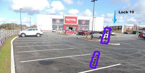 CB150 Churchbridge Flight - Lock
11
CB150 Churchbridge Flight - Lock
11(Use pointer ---- 52.6736, -2.0215 in https://www.google.co.uk/maps )
On the new (2015) Gateway Retail Park looking north-east.
Locks 12 and 11 would have been in this car park.
Lock 10 would have been across the A460 and the corner of Argos, Unit 8, Voyager Drive, Orbital Retail Centre.
Taken looking north-east - 18/2/2016.
------ (More Photos in my Flickr album - Churchbridge
Branch Canal)
(https://www.google.co.uk/maps pointer ---- 52.6732, -2.0222)
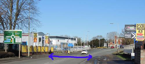
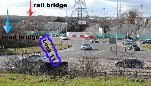 CB170 Churchbridge Flight - Lock
13
CB170 Churchbridge Flight - Lock
13(Use pointer ---- 52.6728, -2.0229 in https://www.google.co.uk/maps )
Railway – canal –
A5 – A34 – A460 – M6toll – opencast
coal mining….. They have all been involved in
obliterating the original canal route here.
The "Church Bridge" is lost under this major
island.
Lock 13 at the start of the Churchbridge flight up to the Cannock Extension Canal would have straddled the island and roadway.
Taken looking south-west from the new (2015)
Gateway Retail Park overlooking the "Churchbridge
Interchange" - 18/2/2016.
------ (More Photos in my Flickr album - Churchbridge
Branch Canal)
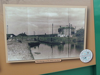 CB180 "Church Bridge"
at A5 Watling Street / A34 Walsall Road junction - Also known as "Cannock Road Bridge"
CB180 "Church Bridge"
at A5 Watling Street / A34 Walsall Road junction - Also known as "Cannock Road Bridge"(Use pointer ---- 52.6724, -2.0235 in https://www.google.co.uk/maps )
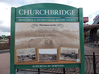
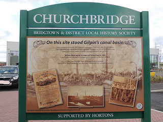
On the new (2015) Gateway
Retail Park – outside Costa Coffee is an information
board from the Bridgetown
and District Local History Society
that includes this image looking south-west --- just
after the lock the canal passed under the sharply forked
junction of Watling Street and Walsall Road. The building
on the right hand side of the photo is the White Lion
Hotel public house (on the far side of Walsall Road at
its junction with Watling Street). To the left of the
White Lion and partly hidden by it are the three bridges
that take Old Mill Stream, the canal and Watling Street
under the railway embankment.
The WYRLEYBLOG (Local History for Great Wyrley and Surrounding Areas) web site has a detailed description of the White Lion Hotel public house and its immediate surroundings - a "must read" for those interested in canals, pubs, railways, roads, factories.............
photo taken at the Gateway Retail Park - 22/2/2016.
------ (More Photos in my Flickr album - Churchbridge
Branch Canal)
(Use pointer ---- 52.6722, -2.0242 in https://www.google.co.uk/maps )
(Use pointer ---- 52.6722, -2.0242 in https://www.google.co.uk/maps )
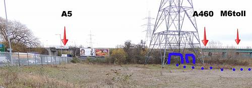 CB220 South Staffordshire
Railway - Walsall to Cannock Branch Line ---- original
line, lost due to development ----
CB220 South Staffordshire
Railway - Walsall to Cannock Branch Line ---- original
line, lost due to development ----(Use pointer ---- 52.6722, -2.0248 in https://www.google.co.uk/maps )
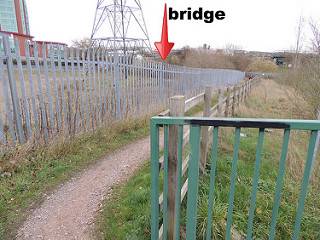
Passing under the railway
– from left to right….
The A5 - canal - Old Mill Stream - A460 - M6toll.
The canal and mill stream would have passed under the railway via a double arched bridge behind the pylon and followed the line of the current footpath and then along the border of the A460/M6toll (off to the right of the photo).
Taken looking east from Lakeside Boulevard - 2/12/2015.
------ (More Photos in my Flickr album - Churchbridge
Branch Canal)
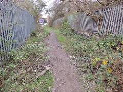
 CB230
footbridge ---- original line, lost due to development
----
CB230
footbridge ---- original line, lost due to development
----(Use pointer ---- 52.6723, -2.0251 in https://www.google.co.uk/maps )
Left --- Footpath with the railway embankment to the right and the A5 straight ahead.
Right --- The canal and Old Mill Stream
passed under the railway via a double arched bridge.
A foot bridge immediately passed over both.
The canal and mill stream would have passed to the right
of the pylon
and followed the line of the current footpath and then
along the border of the A460/M6toll.
The current footpath runs from the A5 – alongside the A460/M6toll – over them – over the proposed route of the new section of the Hatherton Canal - joining on to Littlewood Lane.
At about (pointer ---- 52.6716, -2.0302 in https://www.google.co.uk/maps ) the canal would have turned a little north, passing to the north of the current buildings at Lakeside Business Park / Lakeside Plaza, Walkmill Way.
Galliford Try Partnerships have a Planning Application (in 2016) to build just over 100 homes and a pub – bounded by A5 / A460-M6toll / Walkmill Lane / Lakeside Boulevard.
Taken - 2/12/2015.
------ (More Photos in my Flickr album - Churchbridge
Branch Canal)
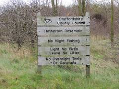 CB240 Reservoir ---- original
line, lost due to development ----
CB240 Reservoir ---- original
line, lost due to development ----The feeder from the Reservoir connected to the Hatherton Branch via the spur to Hawkins Basin.
Taken looking east from the Mill Lane / Hawkins
Drive / Coppice Lane island - 2/12/2015.
------ (More Photos in my Flickr album - Churchbridge
Branch Canal)
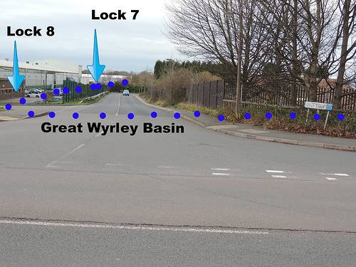 CB250 Walkmill Bridge ----
original line, lost due to development ----
CB250 Walkmill Bridge ----
original line, lost due to development ----(Use pointer ---- 52.6722, -2.0354 in https://www.google.co.uk/maps )
The bridge over Mill Lane /
Walkmill Lane was slightly to the left of the photo.
Further to the left were the spur to Hawkins Basin and
the feeder from the Reservoir beyond the A460/M6toll.
The canal went forwards between Vine Lane and the large
building on the left. Lock 8 – "Bridgetown Lock"
would have been near the front of the building and Lock 7
– "Rosemary Lock" near the back of it.
Great Wyrley Basin would have straddled Vine Lane and
extended into the yard to the right.
Taken looking west from the Mill Lane / Walkmill
Lane - 2/12/2015.
------ (More Photos in my Flickr album - Churchbridge
Branch Canal)
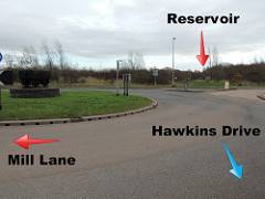 CB290 Hawkins Basin ----
original line, lost due to development ----
CB290 Hawkins Basin ----
original line, lost due to development ----(Use pointer ---- 52.6712, -2.0375 in https://www.google.co.uk/maps )
Hawkins Drive was named in
memory of the now lost Hawkins Basin.
The basin was actually alongside Mill Lane from the
current A460 and the eastbound M6toll carriageway
stretching on to the current waterway that will
eventually become the line of the new Hatherton Canal.
Taken looking east from the Mill Lane / Hawkins
Drive / Coppice Lane island - 2/12/2015.
------ (More Photos in my Flickr album - Churchbridge
Branch Canal)
(Use pointer ---- 52.6726, -2.0361 in https://www.google.co.uk/maps )
(Use pointer ---- 52.6733, -2.0380 in https://www.google.co.uk/maps )
(Use pointer ---- 52.6750, -2.0405 in https://www.google.co.uk/maps )
(Use pointer ---- 52.6751, -2.0408 in https://www.google.co.uk/maps )
2 miles and 3¾ furlongs from Hatherton Junction
(Use pointer ---- 52.6766, -2.0450 in https://www.google.co.uk/maps )
 CB350 Lock 4 - Wedges Mill Lock
- 8ft. 6in. (2.6m)
CB350 Lock 4 - Wedges Mill Lock
- 8ft. 6in. (2.6m)2 miles and 1½ furlongs from Hatherton Junction
(Use pointer ---- 52.6781, -2.0495 in https://www.google.co.uk/maps )
At the site of Wedges Mill Bridge crossing the A4601 Wolverhampton Road.
Looking east at the back of the Linkway Retail Park.
Lock 4 - Wedges Mill Lock to take the canal down under the bridge would have been over the photographer's right shoulder.
The line of the canal back to Churchbridge would have followed the footprint of the building to the right.
Taken looking east from the A4601 Wolverhampton
Road - 18/2/2016.
------ (More Photos in my Flickr album - Churchbridge
Branch Canal)
 CB360 Bridge 9 - Wedges Mill
Bridge
CB360 Bridge 9 - Wedges Mill
Bridge2 miles and 1½ furlongs from Hatherton Junction
(Use pointer ---- 52.6781, -2.0498 in https://www.google.co.uk/maps )
Wedges Mill Bridge under the A4601 Wolverhampton Road.
Taken looking north along the A4601 Wolverhampton
Road towards the A5 - 18/2/2016.
------ (More Photos in my Flickr album - Churchbridge
Branch Canal)
http://www.thehodgkinsons.org.uk/wyrley-walk7.htm
where the rest of the line to the Hatherton Junction on the Staffordshire and Worcestershire Canal is described.